Environmental Policies
Ecuador known as the “country in the middle of the world” supports four distinct natural regions- the Sierra, the Coast, the Amazon, and the Galapagos. The constitution of Ecuador guarantees the right to live in an ecologically balances environment that is free of contamination. In order to protect the delicate and diverse ecosystems Ecuador’s and to uphold the constitution the government has established a system of national parks, scientific stations, and protected areas. In 1993, Ecuador approved the Basic Environmental Principles, a document created by a nationwide discussion with citizen organizations, scientists, journalists, and public representatives. In 1944, the Basic Environmental Principles were established by an Executive Decree which stated the obligations of each person and entity in regards to the preservation of the environment. In 1993, Ecuador was on of the first countries to ratify the Kyoto Protocol on Climate Change, and was the first country to ratify the International Biodiversity Agreement.The Ministry of the Environment was created in 1996 to coordinate environmental policies, programs, and projects. The 1999 Law of Environmental Management incorporates the universal principles of sustainable development contained in the 1992 Declaration of Rio de Janerio, otherwise known as the Earth Summit. The law established principles and guidelines of environmental policies, determined the obligations, responsibilities, levels of public and private protection on environmental management, and set limits, controls, and sanctions. In order to protect the balance of the Galapagos Islands the government approved a law in 1999 that limits agricultural activity, regulates immigration to the islands, monitors invasive species, and promotes the well-being of the local inhabitants and endemic species. Ecuador received a World Wildlife Fund Recognition Award for its sustainable development policies regarding the Galapagos. Ecuador also received the WWFs Gift to Earth Recognition Award for a declaration that protects 1,135,000 hectares of the Amazon Basin rainforest. The declaration prohibits oil drilling, mining, forest destruction, colonization, and any other activity that is a threat to biodiversity (Flores, 2001).
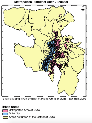
The urbanization process in Ecuador has been accelerated when compared to other Latin American Countries. Cities have been growing so quickly that society has not been abel to conceive and implement social and economic development in order to provide adequate housing, schools, jobs, services, and infrastructure. Migration is the main factor in urbanization, with clear trends of rural to urban migration. By 1990, 55.1% of the population was living in cities. Quito, the capital of Ecuador, has experiences significant demographic growth. Quito, located in an Andean valley between the Pinchincha Volcano and the Intchimbia Hills, is overseen by the 1993 Law of the Metropolitan District of Quito( LDMQ). The Metropolitan District of Quito is made up of urbanized areas, agricultural land, and reserves, parks, and ecologically protected areas. The urban structure has been influenced by the topography of th eland and surrounding mountain systems. The municipality of Quito is an autonomous local government, and assumed responsibility for transport, environmental policies and control, tourism control, and main urban services. The "Quito 21st Century Plan ( Plan Quito Siglo XXI), states that quito will have an ordered space with welfare and solidarity for all, and will have optimal environmental and aesthetic qualities, with its historic and heritage areas being protected, preserved, and used with equity. The government understands how valuable the environment is and has implemented environmental policies at both the national and city-level to protect it 9 Carrion & Vasconez, 2003).
Quito Bus System
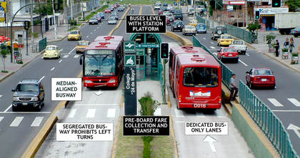
Quito is an important business area that attracts 14% of motorized trips, and in 2000, it was estimated that approximately 75% of the motorized trips were carried out by bus and only 25% by car. Prior to 1996 the bus system operated in a deregulated manner using poorly maintained, privately owned diesel buses. Passengers became increasingly critical of the system and the pollution caused by the old buses, resulting in the Quito Trolebus system. The Trolebus System was implemented by the Transport Planning Department ( Unidad de Planificacion y Gestion de Transporte, UPGT) , a single entity with powers to overcome the challenges in the transport sector.
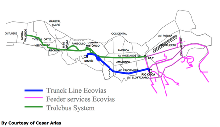
The system uses electrically-powered trolleybuses and operates on a segregated busway separated from the rest of traffic. The first stage of the trolebus scheme is 11.2 km from La Y in the north to El Recreo in the south. The second stage is 4.9 km between El Recreo and Moran Valverde. The busway has surpassed the predicated demand an carries 170,000 passangers a day on average. Access to the bus stops is possible at signal-controlled pedestrian crossings or pedestrian overpasses. The bus system consists in trunk-and-feeder operations, where one pre-paid fair allows interchange between the trunk and feeder buses. In 2002, the Ecovia busway began operations. The Ecovia System is made up up eight operators who formed a company to operate a new service on the busway in agreement with the municipality.
Together, the Ecovia and Quito Trolebus schemes incorporates important elements of mass transit systems: high capacity vehicles, frequent services provided by trunk bus lines, rapid and reliable services, high level image and the appearance of a “quality mode”, and increases service speed on busways. The busway schemes also have many positive environmental impacts, including reduced emissions from the use of electric buses, less buses/transportation services on the road as people chose to take the Trolebus System, and increase in car operating speeds and less stand-still traffic ( Cracknell, 2003).
Quito is an important business area that attracts 14% of motorized trips, and in 2000, it was estimated that approximately 75% of the motorized trips were carried out by bus and only 25% by car. Prior to 1996 the bus system operated in a deregulated manner using poorly maintained, privately owned diesel buses. Passengers became increasingly critical of the system and the pollution caused by the old buses, resulting in the Quito Trolebus system. The Trolebus System was implemented by the Transport Planning Department ( Unidad de Planificacion y Gestion de Transporte, UPGT) , a single entity with powers to overcome the challenges in the transport sector.
The system uses electrically-powered trolleybuses and operates on a segregated busway separated from the rest of traffic. The first stage of the trolebus scheme is 11.2 km from La Y in the north to El Recreo in the south. The second stage is 4.9 km between El Recreo and Moran Valverde. The busway has surpassed the predicated demand an carries 170,000 passangers a day on average. Access to the bus stops is possible at signal-controlled pedestrian crossings or pedestrian overpasses. The bus system consists in trunk-and-feeder operations, where one pre-paid fair allows interchange between the trunk and feeder buses. In 2002, the Ecovia busway began operations. The Ecovia System is made up up eight operators who formed a company to operate a new service on the busway in agreement with the municipality.
Together, the Ecovia and Quito Trolebus schemes incorporates important elements of mass transit systems: high capacity vehicles, frequent services provided by trunk bus lines, rapid and reliable services, high level image and the appearance of a “quality mode”, and increases service speed on busways. The busway schemes also have many positive environmental impacts, including reduced emissions from the use of electric buses, less buses/transportation services on the road as people chose to take the Trolebus System, and increase in car operating speeds and less stand-still traffic ( Cracknell, 2003).
|
|
Cloud Forests
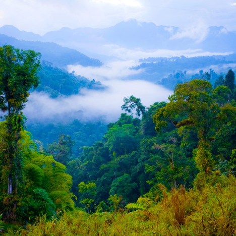
Cloud forests are found in mountainous areas and are very different than low land tropical forests. Cloud forests are formed by the movement of air currents which create clouds and release moisture on the forest, creating condensation on the plants. The altitudes at which cloud forests are formed vary. For inland mountains they may be anywhere from 2,000 to 3,000 meters, where as on coastal mountains the zone can be around 1,200 meters. In extra humid conditions, a cloud forest may be found on coastal mountains at elevations as low as 500 meters.
A cloud forest is usually made up of single story trees that are the same height and is able to support a high a biomass of epiphytes, which represents one quarter of cloud forest species. Epiphytes are organisms that grows on the surface of a plant and takes its moisture and nutrients from the air, rain, and water that accumulate on and around it. One quarter of cloud forest species Typically, as elevation increases the soil becomes wetter and exposure to clouds and wind driven fog causes tree trunks to grow crooked and gnarled. Cloud forests also contain stunted vegetation due to the limited light levels that pass through the clouds.
Cloud forests are vital for stabilizing water quality and maintaining the natural flow patterns of streams and rivers that originate within them. The vegetation in a cloud forest collects water from the clouds, and provides a surface for it to condense and then drip into the waterways. Without cloud forests, there would be a 33% drop in stream flow. These highly unique ecosystems, also called “sky islands”, are sights of rich biodiversity and provide habitat for endemic and threatened species. Eight-six percent of cloud forest are found within the 200 global priority forest ecoregions that have been identified for conservation by the World Wildlife Fund. In addition, cloud forests are the natural habitat of the wild relatives of many crop species, are home to medicinal plants, and are popular ecotourism destinations. Although cloud forests service important environmental and socioeconomic functions for humanity, they are at risk due to logging, infrastructure development, and climate change ( NIHERST Trinidad and Tobago, 2012).
The Andes
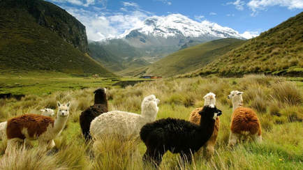
The Andes mountain chain runs 8,000 km through the Americas and passes through Ecuador. The Ecuadorian Andes contain various volcanoes and mountain peaks of all shapes and sizes. The snow capped mountain, Chimborazo, has five separate peaks with the highest one, Whymper, at 6,310 meters. The Tungurahua volcano sits at 5,029 meters and is cone shaped with a white hood of snow around the top. This snow supports a fragile ecosystem and hydrates the land and soil as it creates waterfalls. Cotopaxi sits at 5,897 meters and provides a permanent frozen white landscape and breathtaking views. Cathedrals of ice, known as Illinizas Sur and Illinizas Norte, sit at 5,248 meters and 5,126 meters, respectively. Illinizas Sur has four access routes to the summit and Illinizas Norte has only two. Llamas and Alpacas survive are able to survive in this extreme climate because their blood contains extra red blood cells absorb sufficient oxygen to stay alive at these heights. Quilotoa is a crystalline, salty volcanic-origin lake that sits 3,940 meters high and is 3,000 meters in diameter. The Andean meadows, influenced by the peaks and volcanos, contain many native and colorful flowers and fruits, supporting biologically unique species (ecuadormycountry, 2013).
The Andes mountain chain runs 8,000 km through the Americas and passes through Ecuador. The Ecuadorian Andes contain various volcanoes and mountain peaks of all shapes and sizes. The snow capped mountain, Chimborazo, has five separate peaks with the highest one, Whymper, at 6,310 meters. The Tungurahua volcano sits at 5,029 meters and is cone shaped with a white hood of snow around the top. This snow supports a fragile ecosystem and hydrates the land and soil as it creates waterfalls. Cotopaxi sits at 5,897 meters and provides a permanent frozen white landscape and breathtaking views. Cathedrals of ice, known as Illinizas Sur and Illinizas Norte, sit at 5,248 meters and 5,126 meters, respectively. Illinizas Sur has four access routes to the summit and Illinizas Norte has only two. Llamas and Alpacas survive are able to survive in this extreme climate because their blood contains extra red blood cells absorb sufficient oxygen to stay alive at these heights. Quilotoa is a crystalline, salty volcanic-origin lake that sits 3,940 meters high and is 3,000 meters in diameter. The Andean meadows, influenced by the peaks and volcanos, contain many native and colorful flowers and fruits, supporting biologically unique species (ecuadormycountry, 2013).
Water Sanitation and Services
A variety of interventions may be necessary to ensure access to clean water because water quality and water use patterns depend on environmental, social, economic, and cultural characteristics of a certain are. A study of drinking water storage in northern coastal Ecuador explored the water quality conditions of the initial source as well as the conditions at the point of use. Researchers have observed that storing water in the household leads to deterioration of water quality because of recontamination caused by various factors: size of the storage vessel mouth, transfer of water between containers form collection to storage, hand-to-water contact, dipping of utensils, and bacterial regrowth within the storage container. Recontamination of water in homes who take their drinking water from a poorer-quality source was found to be less pronounced than in homes who take their water from a higher-quality source. The researchers found that 60% of people in the 21 villages studied dispose of human waste by either digging a hole or putting it directly into the river. The same river serves as the primary water source for 68% of households, where 60% of those households do not treat the water prior to drinking. In places where villagers drink directly from the source with no treatment, improving water quality in home storage will not be enough to stop the transmission of water-borne diseases. Household intervention on water storage as well as reducing the sources of contamination in the community and improving sanitation services are keys to breaking the cycle of waterborne pathogens (Levy, Nelson, Hubbard, & Eisenberg, 2008).
Even though Latin America has some of the largest sources of water, including the Andes, Amazon river, and glaciers, the lack of drinking water and contamination of water is having impacts on health, economy, and the war on poverty. For example, in El Salvador, the National Service for Territorial Studies concludes that only 20% of the surface water is safe for human consumption. As the demand for water grows, some countries are taking initiatives to conserve. Chile conserves water by encouraging people to install shower clocks to keep track of the time and install new shower heads with improved technology which will save approximately 25 cents each time the shower is used.
The president of the Ecuadorian’s citizen committee for public services stated that privatizing the water services puts life at risk in poor cities and rural areas, and feels that privatizing water is an unsustainable policy which allows private companies to trample over human rights. The city of Guayaquil, where he is from, is serviced by Interagua, a subsidiary of the water company Bechtel. Alan Snitow, the producer of a documentary called Thirst, also agrees that there are many disadvantages to private water services. He argues that water should be a basic service provided by the government, and that privatization came about because there was a failure of the international system which should provide basic human rights. Wenonah Haunter, the executive director of Food and Water Watch, also agrees that the development model is wrong and that non regulated privatization leads to higher rates, environmental damage, and illness from the water. All three of these people agree that the city of Guayaquil, where water services are provided by the Bechtel company, is a failure.On the other hand, Abel Mejia, Corporate Water Manager for the World Bank, argues that private and government models can be used for water services and that the private model is viable and kept in check by regulations to protect customers. Gonzalo Mejia, producer and director of One Water, also agrees that Guayaquil’s water service from Interagua exceeded expectations and even saved people money (Link TV, 2008).
References
Carrion, D., & Vasconez, J. (2003). Urban Slums Reports: The case of Quito, Ecuador. Quito: Centro de Investigaciones de Ciudad.
Cracknell, J. (2003). Quito Busways, Ecuador.
ecuadormycountry (2013). Ecuador. volcanoes (English Language) [YouTube video]. Available from https://www.youtube.com/watch?v=pUx5HVhY730&feature=youtu.be
Flores, F. (2001). Ecuador's Environmental Policies. Earth Island Journal, 27.
Levy, K., Nelson, K.L., Hubbard, A., & Eisenberg, J. (2008). Following the Water: A Controlled Study of Drinking Water Storage in Northern Coastal Ecuador. Environmental Health Perspectives.
Link TV ( 2008). Latin Pulse- Water Crisis [YouTube video]. Available from https://www.youtube.com/watch?v=dhojFHnfA8E
NIHERST Trinidad and Tobago. ( 2012, April 6). Natural Wonders of the Caribbean 2(2012)- Cloud Forests. Retrieved from https://www.youtube.com/watch?v=NYEilIbX6OQ&feature=youtu.be
Seelke, C. R. (2008). Ecuador: Political and Economic Situation. Library of Congress.
